warehouselogistiek.eu
EN

The platform for internal & external logistics, supply chain and automation
TU Delft and consulting firm "HKV line in water" have developed a precipitation index to compare the risks due to extreme precipitation of cities. The method has been applied to the provincial capitals in the Netherlands. The Hague comes off worst.
Heavy showers increasingly lead to flooding in urban areas. When excess rainwater is not drained quickly enough by sewers, ditches and canals, rain flooding occurs. Due to ongoing urbanization, an increasing percentage of land is paved. But measures can reduce the likelihood and consequences of these floods.
Benchmark
TU undergraduate student Tjerk Krijger, under the guidance of dr.ir. Bas Kolen (TU Delft and consultancy firm 'HKV line in water') and dr.ir. Saskia van Vuren (TU Delft and Rijkswaterstaat), therefore developed a method to determine the risks due to extreme precipitation, interpret the risks and compare cities. The method is based entirely on open data and quantitative analysis, making it reproducible. As a result, cities can be easily compared with each other.
The latest precipitation statistics and models were used to determine the amount of water at ground level during peak rainfall events. The method was applied to county capitals in the Netherlands. Several parameters were quantified to interpret the risk and define ambitions, such as the number of objects that can be affected, the number of inhabitants and the number of reports.
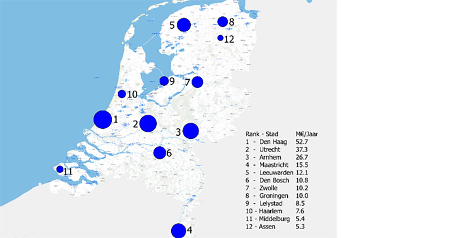
Flood risk related to extreme precipitation for capital cities in the Netherlands. Size of bullet indicates magnitude of risk.
Risk increases
For each city, the risk was calculated and then the cities were ranked according to this risk. This was done for the current situation (2018) and for the future (2050). Due to climate change (higher probability of extreme precipitation), and socioeconomic developments (urbanization and economic growth), the probability and consequence of extreme precipitation is increasing. The study shows that this is the case for all the cities studied.
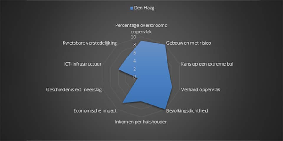
The Hague
Of all the provincial capitals, The Hague has the highest precipitation risk in both 2018 and 2050. It follows from the precipitation index that The Hague has the largest number of buildings affected by extreme precipitation, and the greatest economic impact in the event of precipitation flooding. The high risk is also reflected in the index, The Hague has a relatively large percentage of paved surface and a high percentage of urbanization.
Moreover, for the increase in risk in 2050, the projected economic growth (over 80%) contributes more than the projected increase in precipitation (8%). However, economic development also provides opportunities to use it to reduce precipitation risk.
Reducing risks
The precipitation index shows that for a city like The Hague there are clear handles to reduce or better manage the precipitation risk. For example, more green areas could be created to reduce paved surfaces. Also, parts of the city could be renovated or raised to reduce the number of buildings that could be affected by extreme precipitation.
Encouraging climate adaptation
Using the precipitation index, cities can set concrete ambitions for various parameters and translate them into practical goals. Bas Kolen: 'Our ambition is to develop the method further, with new parameters and improvement of the mutual (risk) relationships. We think that this approach, by comparing cities, is an interesting way to stimulate climate adaptation in municipalities. We want to release an update of this list once every few years for all cities in the Netherlands.'
Text and image: trade magazine Land+Water