warehouselogistiek.eu
EN

The platform for internal & external logistics, supply chain and automation
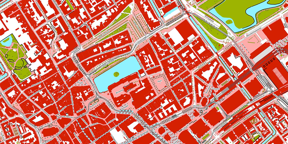
The BGT is the virtual copy of the Netherlands, but according to Jan Bruijn of the SVB-BGT Netherlands Foundation, it is still too little used by GWW companies, despite the good translation possibilities to NLCS. A missed opportunity, because it can bring enormous savings.
All municipalities, Ministry of Defense, Ministry of Economic Affairs, Department of Public Works, ProRail, the provinces and water boards together map the daily changing, physical reality of the Netherlands. "They are the 392 source holders who, as the Samenwerkingsverband van Bronhouders voor de BGT - the SVB-BGT - work daily on the completeness, actuality and uniformity of the BGT," says Bruijn. "Everything you see around you at ground level is mapped, from roads and sidewalks to waterways, bridges, ditches and agricultural parcels. The map is detailed to within 30 centimeters in built-up areas and 60 centimeters outside of them."
The SVB-BGT Foundation processes as many as 40,000 (!) mutations daily from all over the country. Bruijn: "The data are forwarded to the Kadaster and published in pdok. The map is thus available in all kinds of formats and can be perfectly translated into NLCS, the CAD standard of the Dutch GWW sector. It is then actually quite logical that GWW companies take the BGT as a starting point for an up-to-date picture of the situation. People know about the existence of the map, but are mostly unaware of the good translation possibilities to NLCS."
The BGT is currently still a virtual 2D copy of the Netherlands, but Bruijn says work is underway on a 3D variant, as well as a link with the Basic Registration of Addresses and Buildings and an integration for WOZ. "It only offers advantages for GWW companies. The organization of a detour can be determined precisely with the BGT and soon you will also be able to see immediately which addresses you need to write to if you are going to open up a road. Information from the BGT also helps to greatly ease the work preparation and calculation process."
For example, The People Group already creates designs for fiber optic networks or water pipes, based on the BGT. "Because of the timeliness and accuracy of the data, they can design an exact network. This allows them to determine the location, calculate materials and work, which ultimately saves costs. In addition, the BGT contains the physical appearance of roads. Very useful to precisely determine the work to open existing pavement and lay the cable," Bruijn concludes.